

| In the summer of 1608, John Smith led two expeditions out from the fort at Jamestown to explore and map the Chesapeake Bay. These voyages of exploration are described in great detail in his The General History of Virginia, New England, and the Summer Isles, which also includes his famous map of the Chesapeake Bay. The map was made during these two voyages, and includes many details such as Indian villages, the homes of the different chiefs, and other valuable information about the region. | 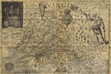 |
| Using the General History as a guide, Virtual Jamestown was able to reconstruct John Smith's voyages. They have been reconstructed as an interactive Flash map, and can be viewed by anyone with the Flash plug-in (Flash 4 or higher), available from Macromedia. To view the voyages, select either from the menu at the top. The voyage will start automatically, and can be paused, stopped, and restarted using the buttons at the bottom of the menu. In addition, the timeline at the top of the menu can be used to navigate through the voyage day-by-day by clicking above the dates. | |
| View the John Smith Voyages Map | |
| Sources used in the creation of the John Smith Voyages map:
Haile, Edward Wright. Jamestown Narratives - Eyewitness Accounts of the Virginia Colony, The First Decade: 1607-1617. Champlain, Virginia: RoundHouse, 1998. (pgs. 254-278) Haile, Edward Wright. Virginia Discovered & Discribed by Captayn John Smith, 1608 - an adapted map by Edward Wright Haile identifying the John Smith locations on a modern map. | |