
| Native Americans, 1600 | |
|
From the Virginia Geographic Alliance |
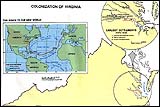 |
| Colonization of Virginia | |
|
From the Virginia Geographic Alliance |
|
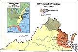
| Settlement of Virginia 1607-1700 | |
|
From the Virginia Geographic Alliance |
 |
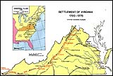
| Settlement of Virginia 1700-1775 | |
|
From the Virginia Geographic Alliance |
 |
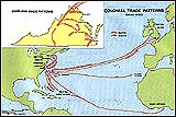
| Colonial Trade Patterns | |
|
From the Virginia Geographic Alliance |
 |
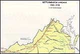
| Settlement of Virginia 1700-1775 | |
|
From the Virginia Geographic Alliance |
 |
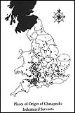
| Places of Origin of Chesapeake Indentured Servants | |
|
From historian James P.P. Horn. (Reproduced in Albion's Seed, 238) |
 |
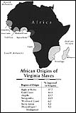
| African Origins of Virginia Slaves | |
|
Courtesy, Virginia Historical Society; Table, Philip D. Curtin, The Atlantic Slave Trade, a Census |
 |
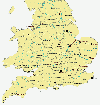
| England County Boundaries and Major Cities in the 1600's | |
|
Image adapted from a map created by The Association for the Preservation of Virginia Antiquities |
 |
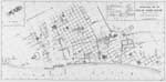
| John Cotter's Archaeological Base Map of the Site of "James Towne" | |
John Lambert Cotter dedicated his life to archaeology. He received his B.A. and M.A. at The University of Denver and his doctorate in Anthropoplogy at The University of Pennsylvania. His book Archeological Excavations at Jamestown, Virginia was published in 1958, and documents the archeological work done there between 1934 and 1957. This is the base map that accompanies the book, showing their discoveries during that time.
|
 |

|
|
|
©Crandall Shifflett |