

| John Smith's Map of Virginia, 1608 | |
|
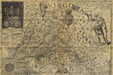
John Smith's "Virginia" was originally published separately in London in 1612 and then in the 1612 Oxford publication of John Smith's A Map of Virginia: With a Description of the Countrey, the Commodities, People, Government and Religion. Subsequently it appeared in several other works by Smith and other commentators on Virginia. It remained the most influential map of Virginia until the last quarter of the 17th century and many of the place names used by Smith remain in use. |
 |
| John Smith's Map of Virginia, 1608 (Modified) | |
|
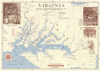
This is a version of the John Smith map modified by Edward Wright Haile (Globe Sales, c/o RoundHouse, P.O. Box 155, Champlain, Virginia, 22438-0155). He has removed much of the "busyness" of the original map, and added lines showing the two exploratory voyages taken by John Smith. |
 |
| Zuniga's James Fort, 1608 | |
|
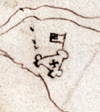
This is the only known sketch of the fort. It appears on a tracing of a 1608 John Smith map of Virginia sent to Philip III of Spain by his ambassador Pedro de Zuniga. Scholars believe that the “x” marks the church and the “flag” area was not a flag at all but a plan of an enclosed settlement or garden to the north. The small dots may indicate watch towers on the river. |
 |
| Vingboons Dutch chart, 1638 | |
|
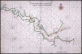
This chart entitled "Caert Vande Riuer POWHATAN Geleg in Niew Nederlandt" was drawn by the Dutch cartographer, Johannes Vingboons after 1638 from ca. 1617 ships' logs. It was included in the his publication of Atlas of the Dutch West India Company. It illustrates Jamestown, individual houses around modern Hopewell, and two other early Virginia forts: Fort Algernon at Point Comfort and Charles Fort at Strawberry Bank. It is significant in its illustration of the Jamestown fort as not being at the western site previously thought to be its location. |
 |
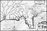
| Florida et regiones vicinae, 1625 | |
|
Joannes de Laet created this map in 1625. Map text is in Latin. The map covers mainly the Florida and Gulf of Mexico area, although it does stretch as far North as Virginia. The original map is held by the Hargrett Rare Book and Manuscript Library of the University of Georgia Libraries. |
 |
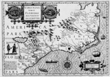
| Virginiae item et Floridae, (Mercator, 1633) | |
|
This map first appeared in Gerhard Mercator's atlas published in 1633. The map text is in Latin. It includes several descriptive images, including: images of Florida and Virginia Indian villages, on the left and right of the map respectively; European and Indian boats; the dress of male and female Floridan Indians, and several fish/sea monsters. Indian names noted in the Virginia area correspond to those found on John Smith's map of Virginia shown above. |
 |
| Jamestown Fort, 1607 | |
|
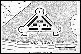
This map is found in the book Jamestown and St. Mary's: Buried Cities of Romance by Henry Chandlee Forman (Baltimore: The John Hopkins Press, 1938, pg. 39). He created an approximate reconstruction of the plans of the Fort based on early descriptions and the Pedro de Zuniga map shown above. |
 |
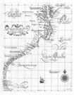
| Carta particolare della costa di Florida e di Virginia (Dudley 1646) | |
|
This map was created by Sir Robert Dudley in 1646, and engraved by A. F. Lucini. The map legend and labels are in Italian. The original map is held by the Hargrett Rare Book and Manuscript Library of the University of Georgia Libraries. |
 |
| John Farrer Map, 1651 | |
|
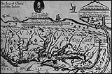
John Farrer's "A mapp of Virginia discovered to ye Hills" was originally drawn in hand and included in Farrer's personal copy of Edward William's Virgo Triumphans: or, Virginia richly and truly valued. The engraved version was included in the third edition of that book published in 1651. Farrer was a prominent member of the Royal Company of Virginia and an ardent promoter of the new colony. He even named his daughter after the colony. Farrer's map is significant due to the narrow depiction of North America with a Northwest Passage shown as a river connecting the Hudson River to the "Sea of China and the Indies." |
 |

|
|
|
©Crandall Shifflett |